Major storm brewing off the coast likely to bring rain and wind
Published 3:55 pm Sunday, November 17, 2024
- An intense low-pressure system could rival the infamous Columbus Day Storm, a leading forecaster suggests, but is likely to remain offshore.
Mother nature is expected to throw all sorts of weather potentials at Southwest Washington over the next week, including rain, wind and even the potential for snow. Weather models are all over the place with predictions.
Trending
A Pacific-style hurricane
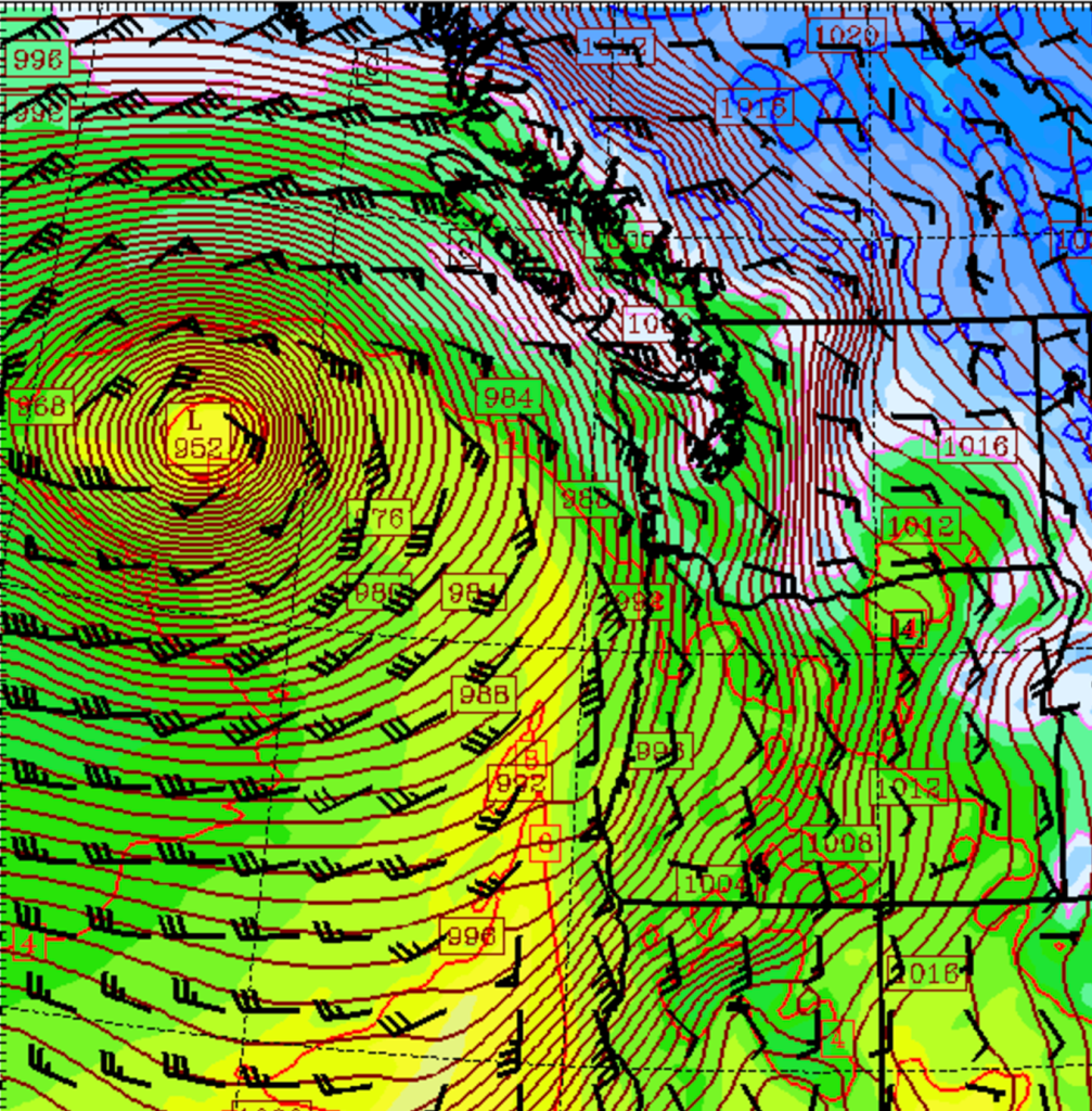
University of Washington Meteorology Professor Cliff Mass delved into the storm’s strength in recent online posts. On Nov. 17 he suggested it could compare with one of the strongest storms in decades with winds offshore equivalent to a Category 1 hurricane.
The storm will begin impacting Washington on Tuesday, Nov. 19.
“The latest sea level pressure forecast for Tuesday is scary, with an intense 952 hPa low center west off the Washington coast,” Mass said on his blog. “The strongest storm ever to hit the Northwest during the past century, the Columbus Day Storm of 1962, had a low-pressure center of 950 hPa.”
“The sustained wind speeds at the same time are shown [on the blog]. 70 kts [80 mph] and more around the storm — hurricane strength. The [British Columbia], [Washington], and Oregon coastal zones will get a taste of it. Expect some coastal power outages,” Mass added.
Mass’s forecast suggests the coast will see wind gusts of 60-70 mph.
“The sea-level pressure forecast for Tuesday at 7 PM by the European Center model shows an intense low center with a central pressure of 944 hPa due west of the Washington Coast,” Mass said Nov. 16.
“Trust me, this is an unusually deep low, with most Pacific low centers at this latitude only deepening to 980-990 hPa,” Mass added.
The National Weather Service (NWS) in Portland is being reserved in their predictions for the storm. The agency predicts a 5-20% chance of wind gusts over 45 mph for the inland region and a 60-70% for the coast on Tuesday.
“[We] will need to closely monitor how guidance chooses [to resolve] this system the next couple of days as it may end up leaning to high-level impacts should it trend towards the noted [worst] case scenario,” the NWS Portland stated.
Inches of rain
The biggest weather story this week is likely going to be rainfall, a lot of it. The NWS has already issued a Hydrologic Outlook saying the most probable projection totals for the coast and coastal range are 3.5 to 6 inches of rain between Wednesday, Nov. 20, and Saturday, Nov. 23. The worst-case scenario is up to 11 inches of rainfall.
“Regardless of the exact strength/duration of the atmospheric river and exact rain amounts, flooring is possible in low-lying urban areas as well as for our flashier rivers in and along the coast/coastal range,” the NWS Portland stated.
“The latest [Hydrologic Ensemble Forecast System] guidance is showing coastal rivers having a 25-50% chance of reaching minor flood stage within the next ten days, except for the Wilson River near Tillamook and Siletz River at Siletz which have a 60-70% chance. There is also around a 10-40% chance our coastal rivers will hit a major flood stage,” the NWS Portland added.
At present, the Center for Western Weather and Water Extremes predicts that the most severe scenario for an Atmospheric River is a grade 2, meaning it would be “mostly beneficial but potentially hazardous.”
Pacific County Emergency Management Agency Director Scott McDougall is closely monitoring the forecast.
“We want everybody to be prepared, and we have sandbags ready at the usual locations,” McDougall said while also adding that the fact the rain is being spread over 3-4 days bodes well since the usual worst-case situation is significant rainfall over a 24-48 hour period.
Snow potential overnight
The European Center for Medium-Range Weather Forecasts (ECMWF) model, an often aggressive forecasting model, is suggesting a potential for snow in the north county region overnight tonight into the morning of Monday, Nov. 17.
The model shows the Raymond area receiving the most snowfall, with up to 4.4 inches by 10 a.m.
Other forecast models, including the Global Forecasting System, show no snowfall affecting Pacific County.
As with any storm in the Pacific Northwest, anything is possible. It’s important to take the forecast with a grain of salt, but at least be prepared. The storm coming Tuesday, Nov. 19, is worth some attention.
Marketplace


-
eEdition

-

-
