Quake excites fears of a tsunami: Highest impact here was 6 inches
Published 5:57 am Monday, August 4, 2025
PACIFIC COUNTY — One of the strongest earthquakes in recorded history generated an hourslong game of wait-and-see last Tuesday, July 29, as seismologists pored over data to determine if — and where — the tsunami it had generated posed a risk to life and property.
Here on the Washington coast, local and regional emergency managers juggled between keeping the public informed about a potential threat still hours away from reaching shore while staying up to date on the latest developments and guidance. By the following morning, any worries about danger to the Long Beach Peninsula had passed.
Large quake recorded
Trending
At 4:25 p.m. on July 29, an earthquake with an initial 8.0 magnitude was recorded about 50 miles off Russia’s eastern coast at a depth of about 12.8 miles. About 10 minutes later, the National Tsunami Warning Center (NTWC) based in Palmer, Alaska issued emergency bulletins for coasts all across the Pacific Ocean, from Russia, Japan and Alaska’s Aleutian Islands to Hawaii, Chile and, yes, on the west coast of the U.S. and Canada.
“Based on all available data a tsunami may have been generated by this earthquake that could be destructive on coastal areas even far from the epicenter,” one such bulletin meant for the Hawaiian Islands stated, while a message intended for the coasts of Washington, Oregon, California and British Columbia said “the level of tsunami danger is being evaluated.”
Shortly after that report, the Pacific County Emergency Management Agency (PCEMA) said in a post on its Facebook page that it was monitoring the threat level and would share further information when it received further updates.
At 5:19 p.m., about 45 minutes after its initial bulletin, the NTWC announced that a tsunami watch had been put in effect for the U.S. and Canadian west coasts — meaning a tsunami was possible but not inevitable, and any arrival time is still several hours away — and that people should prepare to take action if necessary.
The magnitude of the earthquake was also revised upward significantly, to an 8.7 and later an 8.8, making it more than six times bigger and nearly 16 times stronger than an 8.0 magnitude earthquake. It’s tied for the sixth-strongest earthquake ever recorded, and tied for the third-strongest in the 21st century.
Following the NWTC’s latest bulletin, PCEMA sent out an alert via text message and on its Facebook page at 5:23 p.m. that a tsunami watch had been issued. The agency stressed that it was still unknown if a tsunami would impact our coast, but that the first wave would arrive sometime around 11:30 p.m. if it did and that more would be learned over the course of the next hour.
Trending
Advisory issued
Sure enough, at 6:27 p.m., the NTWC upgraded the watch to an advisory, and forecast 11:45 p.m. as the initial arrival time for the Long Beach Peninsula.
Under tsunami advisories, which are typically issued for waves projected to reach a height of no more than three feet, people are advised to stay out of the water and away from shore because of the strong currents and dangerous waves that can still be generated.
The highest alert level, tsunami warnings, are for when wave heights are projected to exceed three feet — in the most threatening cases, widespread evacuations to move inland or to higher ground are ordered.
Excited public
It was expected early on during the incident that the coast would likely not see any major impacts, although that did not appear to calm some nerves. Residents tied up dispatchers at the Pacific County 911 Communications Center (PacCom) for hours with countless 911 and non-emergency line calls asking, “what do we do… is this real… is the tsunami going to hit?”
“We actually ended up calling in extra staff and I stayed myself,” PacCom Director Cait Ochoa said. “The number of 911 calls we received show that too many in our community are unsure how to respond. We need to do a better job educating the public, and our citizens need to take the time to learn evacuation routes and safety steps before an emergency happens.”
“If you are in a tsunami evacuation zone, move to higher ground immediately. Do not wait for instructions, and only call 911 for life-threatening emergencies. Safety starts with quick action,” Ochoa added.
Dispatch wasn’t the only entity that was lively during the event.
PCEMA partially activated the Emergency Operations Center. Director Scott McDougall and Coordinator Marcelina Medina worked throughout the event preparing immediate actions and dispersing info to the public.
“This event highlights a need for ‘whole community’ preparedness,” McDougall said. “It also highlights the fact that preparedness is a personal responsibility. Also, we will be educating people on what actions to take following a distant source earthquake, where you do not feel the earthquake.”
“In these instances, if a tsunami warning is issued, we will be providing specific evacuation instructions. Most of the peninsula will be able to shelter in place. Unnecessary evacuations could cause more harm than the tsunami itself,” he added.
Low risk this time
By 7:25 p.m., still more than four hours before the expected arrival time, the NTWC forecast that the tsunami hitting the peninsula would reach a maximum height of less than one foot. The ensuing messaging from PCEMA in its alerts was simple: “Evacuations are not being ordered, but please simply stay away from the water and beaches until further notice.”
“Tsunami advisories are not our ‘normal’ state. This situation causes stress and fear for people, especially during a time when so many tourists are in our community,” the agency said online, noting the agency was working to gather and share information with the public “to help keep people calm during this stressful time.”
PCEMA stressed that, if the situation were to become more serious, it would “use every tool in our tool box to alert the public with as much lead time as possible,” including utilizing reverse 911 calls, All Hazard Alert Broadcast (AHAB) sirens, Emergency Alert System (EAS) messaging, and NOAA weather radios.
At 10:27 p.m., more than an hour before the forecast arrival time, the National Weather Service informed PCEMA that while the estimated wave heights remained at one foot or less, the increased wave action generated by the tsunami could last anywhere from 9-15 hours. Subsequently, the agency urged people to remain off the beach through the following afternoon.
A middle-of-the-night update from PCEMA at 2:32 a.m. on Wednesday, July 30, confirmed that observed wave heights had been “well below one foot,” but that the tsunami advisory remained in effect. Another update a few hours later, at 6:54 a.m., said wave impacts to Pacific County’s beaches had been “minimal,” and it was anticipated that the advisory would be lifted later that morning.
Tsunami ripples lasted over 48 hours
Tsunamis typically aren’t isolated to just one swell and usually come in long-duration flurries.
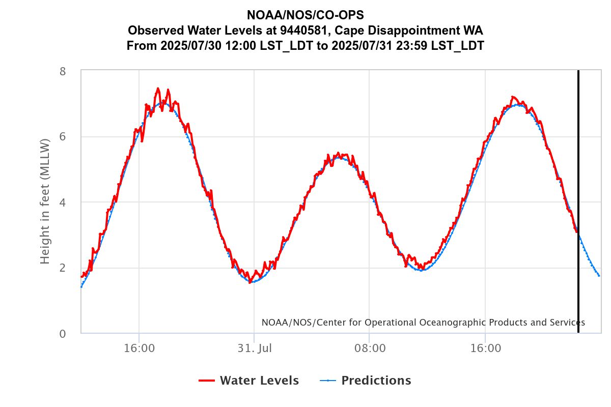
Weather watchers kept their eyes peeled at water level meters up and down the west coast for any indicators of the first waves hitting. These water level meters show two specific tidal data points — a blue line that indicates the forecast tidal level, and a red line showing the actual observed height.
On the data, tsunamis show up as quick up-and-down gyrations on the meters.
Those interested can find these meters by visiting tidesandcurrents.noaa.gov and then clicking on Washington on the map, which link a map of the meters. Updates about tsunami alerts can be found at tsunami.gov, which is the U.S. Tsunami Warning Centers’s online hub.
Water level markers at Cape Disappointment and Toke Point were closely monitored the entire night of July 29-30. The actual time of arrival of the first wave at Cape Disappointment ended up being about 12:30 a.m. on July 30 — 45 minutes after what had been expected.
Toke Point saw its first wave at 12:54 a.m. on July 30.
The data shows that the first wave was 4.3 inches at Cape Disappointment and 2 inches at Toke Point. The water level meters showed tsunami waves hit for close to 48 hours. The largest follow-up swell at Cape Disappointment was 6 inches at 5:17 p.m. on July 30 and at Toke Point was a quarter-inch at 11:12 p.m. on July 30.
Marketplace


-
eEdition

-

-
