Weather outlooks point to a frigid winter
Published 1:13 pm Monday, September 2, 2024
- Lower winter temperatures are predicted to take hold more likely than not in our corner of the country.
The winter outlook for 2024-25 is interesting for the Pacific Northwest, thanks to the transitions to a La Niña weather pattern. Take it for what it’s worth, but La Niña winters can often be a roller coaster.
Trending
La Niña winters usually involve colder temperatures due to Arctic air dripping down from the north and an increase in winter precipitation from the west. The polar jet stream is known to aim directly at Washington state, leading to increased precipitation and increased odds of severe flooding.
This will be the Pacific Northwest’s third La Niña winter in the past four years, with only the 2023-2024 winter breaking up what could have been a four-peat. The 2022-2023 winter was graded as a “weak” La Niña winter, and the 2021-2022 winter was graded as “moderate.”
El Niño is the opposite, with a warmer and drier winter season. Neutral years are a toss-up and can produce mild to severe weather.
Trending
If you think back, the 2021-2022 winter was rough for Pacific County. Heavy snowfall over December 2021 and January 2022 resulted in feet of snow in the Willapa Hills. The county was then hit with a mid-January 2022 warming spell and heavy rain — which caused significant localized flooding.
The combination of snowmelt, rainfall and mountain runoff pushed local rivers up and small estuaries to their brim. South Bend took the brunt of the issue with a combined high tide that resulted in tidal overflow flooding that damaged more than a dozen homes.
The main takeaway is that this winter could pack a punch, and seasonal outlooks are already upping the ante. The National Weather Service and Farmer’s Almanac call for cold and increased precipitation.
According to the NWS three-month outlooks, September 2024 through November 2024 is expected to remain near normal temperatures with above-normal precipitation. The precipitation is in the 40-50% tier, which means it’s more probable.
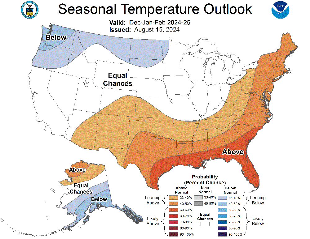
Things appear to ramp up from December 2024 through February 2025. The outlook predicts below-normal temperatures in the 50-60% tier, meaning a favorable likelihood, and above-normal precipitation in the 50-60% tier, again meaning a favorable likelihood.
The outlooks continue the trend through approximately April 2025, with below-normal temperatures and above-normal precipitation. As we have seen in the past, Pacific County is no stranger to late-season snowfall well into April.
Likewise, the Farmer’s Almanac predicts an outlook similar to the NWS’s. It specifically says, “cold and snowy.”
“Precipitation and snowfall will be above average in the north [Washington state] and below average in the south [Northern California]. The snowiest periods will be late December, early January, and early February,” the outlook states.
“Winter temperatures will be colder than normal in the north [Washington] and warmer in the south [Northern California]. The coldest periods will fall in early and late January and early March,” the outlook also states.
Although the overall outlook looks wintry, the next couple of weeks show temperatures still remaining in the upper 70s, including later this week. Thursday, Sept. 5, is looking to be downright hot, with most of the county hitting the 80s to low 90s.
It is safe to say that until University of Washington Professor Cliff Mass, a well-regarded meteorologist, officially declares the start of the meteorological fall, La Niña’s grasp on the Pacific Northwest hasn’t taken hold.
Mass usually makes the declaration on his online blog. We will watch for updates on the seasonal change.
Marketplace


-
eEdition

-

-
