Turkey quakes have lessons for Pacific NW
Published 7:52 am Monday, February 13, 2023
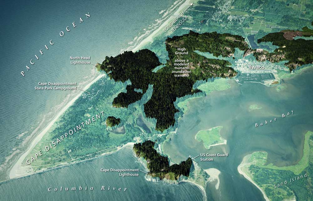
- The peninsula’s southern highlands are shown with the surrounding area as it might be inundated in a major Cascadia Subduction Zone tsunami.
It’s another wakeup call for the Pacific Northwest.
Trending
The series of earthquakes that has killed more than 35,000 Turkish and Syrian people as of Feb. 13 is a different beast from the big “subduction” zone quake lurking in Western Washington’s future.
‘We are certainly in better shape than we were. But we have plenty of work to do, and that includes schools.’
Harold Tobin, director of the Pacific Northwest Seismic Network
Trending
Nevertheless, the disaster has significant lessons and reminders for our region, most notably that it still is not prepared well enough, Harold Tobin, director of the Pacific Northwest Seismic Network, said last week.
Improved building codes, retrofits of bridges and old buildings and other safety steps make the region better prepared for the multiple seismic hazards that scientists have identified in the region over the last four decades.
“We are certainly in better shape than we were. But we have plenty of work to do, and that includes schools, ” Tobin said. “We are going to have strong shaking and we will have damage and destruction and loss of life from it — I hope not on the scale we’re seeing in Turkey, but there still clearly is work to do.”
Domino effect
Among the important takeaways from the Turkish quakes is that one earthquake can have a domino effect and spawn a separate temblor on a different, adjacent fault, expanding the scope of the shaking and damage.
The earthquakes in Turkey occurred where three “tectonic” land masses — the Arabian, Anatolian and African — collide and try to grind past one another in the southeastern part of the country.
Over centuries, this collision built up stresses in the earth’s crust that were suddenly released, causing 7.8 and 7.5 earthquakes. The force was immense. One fault may have “ruptured”— or slipped — over a distance of hundreds of miles. Violent shaking occurred over a broad area. The U.S. Geological Survey said the land in some cases shifted 10 feet sideways.
No wonder thousands of masonry buildings — which are brittle, not flexible like wood structures — collapsed, trapping and crushing people in the rubble.
Besides their potency, one of the noteworthy aspects of the Turkey quakes is that the jolt from the first — the 7.8 — almost certainly triggered the second — the 7.5 — along a separate fault just 60 miles to the north, Tobin said.
This has relevance for Western Washington, which is laced with many shallow “strike slip” faults (sideways moving) like those involved in the Turkish events. There’s one under downtown Seattle and Bainbridge Island, and others cut beneath Whidbey Island, Tacoma, Mount St. Helens and downtown Portland, among others places.
Can the shock of an earthquake along one of these have a domino effect and cause some of the others to rupture, too? There is no estimated likelihood that this can happen here. The probability is low, but the Turkish temblors show it is possible, Tobin said.
Hazards assessments “cannot view these faults in isolation,” he said.
Shallow vs. deep
Shallow earthquakes tend to be much more damaging than deep quakes of comparable magnitude (such as the deep, 6.8 Nisqually earthquake in 2001). This is primarily because in deeper earthquakes, seismic shock waves lose more energy by the time they reach the surface, according to seismologists.
The shallow Mount St. Helens fault is capable on its own of producing magnitude 7 earthquakes, though the more likely strength is 5.5. A temblor that big occurred there on Feb. 14, 1981, causing considerable shaking in some of Southwest Washington but relatively little damage.
The fault stretches nearly 100 miles northwestward of the volcano possibly to the Puget Sound lowlands. A magnitude 7 would affect 14 counties, cause light to moderate damage to thousands of buildings and about $100 million in losses, according to a state/federal estimate. Though large, the projected losses are somewhat moderate because the fault cuts through sparsely populated areas.
The Seattle Fault also has potential to cause a magnitude 7 earthquake, but because it would occur right under downtown it could be far more destructive and deadly. The odds for one to occur are 5% for a 6.5 quake in the next 50 years, according to seismologists. The last occurred about 1,100 years ago.
Its estimated potential strength is significantly less than the Turkish earthquake (a magnitude 7 is 30 times more powerful than a magnitude 6). But it still will be a monster that causes damage and death in Seattle on the scale of the 1995 earthquake that killed nearly 5,000 people and injured 14,000 in Kobe, Japan.
Cascadia Subduction Zone
Tobin said scientists have not seen much evidence that any of the shallow Western Washington faults could be triggered by a “megathrust” earthquake (magnitude 9.0 or greater) along the undersea Cascadia Subduction Zone. That’s the 900-mile long offshore fault where North America is colliding with the Juan de Fuca tectonic plate, forcing it to dip (or subduct) into the earth’s mantle.
The last such quake there occurred in January 1700, and scientists estimate the chance is 10% that the next will occur within 50 years.
Big and long structures — such as the Astoria-Megler Bridge and the Lewis and Clark Bridge between Longview and Rainier — will be especially vulnerable in a subduction zone quake, which could cause shaking for more than four minutes. It will spawn giant tsunami waves on the coast that will hit the beaches and lowland in as little as 15 minutes.
That’s not enough time for people to reach high ground, especially because roads and power lines already will have been extensively damaged by the earthquake. This threat is leading to some of the most visible earthquake preparedness measures in the region.
Coastal communities in Washington and Oregon — with state and other assistance — are creating elevated tsunami evacuation structures.
In August, the Shoalwater Bay Indian Tribe dedicated a 50-foot tall steel evacuation tower in Tokeland, a flat expanse at the north end of Willapa Bay in Southwest Washington. It could offer refuge for up to 400 people and will be open to all in an emergency, according to a National Public Radio report.
We need 50 more
The tower is the first of its kind in the U.S. and is similar to tsunami evacuation towers built in Japan, where a subduction zone earthquake and tsunami in 2011 killed 15,500 people and contributed to the meltdown of three nuclear reactors at the Fukushima Daiichi Nuclear Power Plant.
Reinforced tsunami evacuation platforms also have been built on the roofs of school buildings in Newport, Oregon, and Westport, Washington. A new school built in Ocosta in Grays Harbor County was the nation’s first vertical tsunami evacuation Center. At 53 feet above sea level, the rooftop evacuation platform sits high above the school commons and gymnasium. It includes 23 classrooms, a library, food service kitchen, administration office, and other support spaces.
“We need about 50 more” tsunami escape structures, Maj. Gen. Bret Daugherty said at the Tokeland tower dedication. He heads the Washington National Guard and state Military Department, which houses the Emergency Management Division.
This is the kind of preparedness the region needs to continue to avoid catastrophic deaths on a scale that occurred in Turkey and Syria.
As a Shoalwater tribal leader told NPR at the tribe’s tsunami tower dedication: “This tower will save our lives someday.”
Marketplace


-
eEdition

-

-
