La Niña dominates NOAA’s winter outlook
Published 5:00 pm Thursday, October 20, 2022
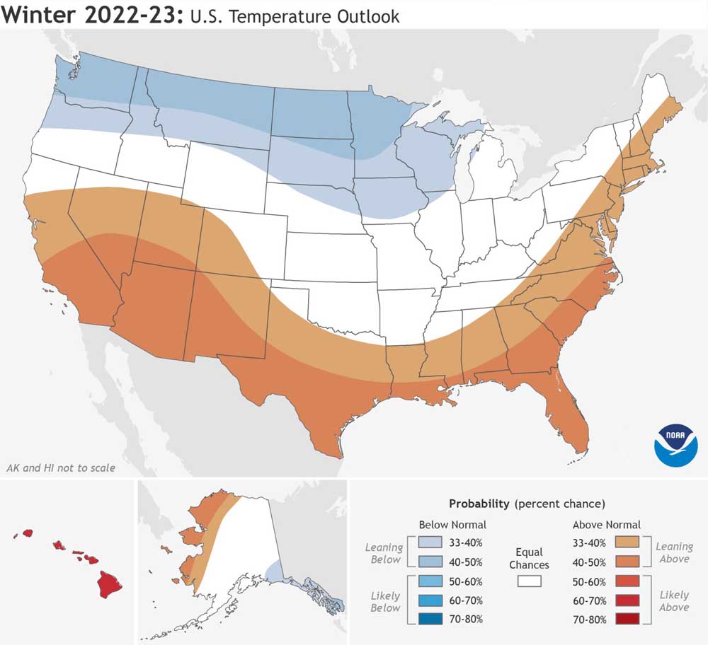
- Washington and other northern-tier states in the western two-thirds of the nation are likely to be cooler than normal this winter.
Drought conditions in Washington, Idaho and Oregon should improve this winter, but worsen in much of the West, the National Oceanic and Atmospheric Administration predicted Oct. 20.
Trending
NOAA primarily based its outlook for December, January and February on a La Niña expected to prevail for a third straight winter.
La Niña winters are typically cold and wet in the northern tier of states, but warm and dry in the southern U.S. La Niña’s effects are most pronounced in the Lower 48 in far north or far south.
‘As you go farther to the north to Washington, we feel that there is more likelihood for above-normal precipitation there.
Trending
Jon Gottschalk
Chief of the Climate Prediction Center’s forecasting branch
For regions in between, such as Southern Oregon, Southern Idaho and Northern California, La Niña winters can be mild, harsh or average. Climatologists consider it a toss-up.
Drought conditions in much of Eastern Oregon and northwestern California should improve, but not disappear, according to forecasters. Drought likely will be erased in Washington, northern Oregon and much of Idaho.
Washington irrigators are among La Niña’s biggest beneficiaries. The ingredients for a large snowpack, below-average temperatures and above-average precipitation, are likely for the state, according to NOAA.
Winter will vary greatly along the West Coast, said Jon Gottschalk, chief of the Climate Prediction Center’s forecasting branch.
“As you go farther to the north to Washington, we feel that there is more likelihood for above-normal precipitation there,” he said.
Drought likely will worsen in Southern California, the Southwest and the Great Plains, and develop in the Southeast and south Texas, forecasters said.
A third-straight La Niña winter is rare. Since 1950, it’s happened two other times. The last time was the winter of 2000-01. The La Niña was weak and Washington’s snowpack was below average.
The time before, the winter of 1975-76, the La Niña was strong and the snowpack was above average.
This La Niña probably will be a “moderate event,” but a La Niña’s strength doesn’t fine-tune forecasts, Gottschalk said.
“With La Niñas, to be honest, there is not much predictability in impacts [based on] whether they are weak, moderate or strong,” he said.
A hot and dry summer and fall have brought on drought in Washington after an extremely cold and wet spring.
Some 61% of the state was in a drought Oct. 20, the U.S. Drought Monitor reported. Much of Western Washington was in a “severe” drought.
Drought conditions are more widespread and deeper in Oregon. Some 80% of the state is in a drought. Portions of Eastern Oregon are in “extreme” or “exceptional” drought.
The region should get relief soon, NOAA drought forecaster Brad Pugh said.
“Right now, we’re seeing a major pattern change unfolding near the West Coast,” he said. “It looks like a much wetter pattern for Washington, Oregon during late October until at least the beginning of November.”
La Niñas are triggered by below-average sea-surface temperatures in the Pacific Ocean. El Niños are caused by warm seas. Washington’s 2015 snowpack was during an El Niño.
La Niña influences the weather over an entire season. Shorter-term events, such as “atmospheric rivers,” also will influence whether an area has a wet or dry winter, climatologists said.
Ocean temperatures in the north Pacific also could affect the seasonal weather, they said.
Marketplace


-
eEdition

-

-
