Beneath the forest: LiDAR reveals our complex land, made naked
Published 10:00 am Tuesday, July 19, 2022
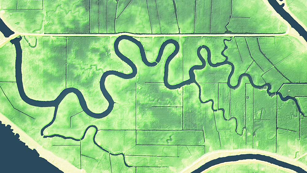
- Puget Island, a large island in the Columbia River immediately south of Cathlamet, has been extensively farmed, canaled and diked for generations. This LiDAR image shows now-filled creek and slough channels, along with a detailed look at man-made modifications.
It’s hard to imagine our place without all its towering trees, tangled bushes and ancient ferns. Thanks to a relatively recent technological innovation, we no longer have to imagine.
Trending
As explained in a remarkable online presentation, The Bare Earth (tinyurl.com/DNR-Bare-Earth):
“LiDAR (light detection and ranging) is a technology that uses light pulses to collect three-dimensional information. LiDAR data is often collected from an airplane using a laser system pointed at the ground. The system measures the amount of time it takes for the laser light pulses to reach the ground and return. Billions of these rapidly-collected measurements (points) can create extremely detailed three-dimensional models of the Earth’s surface.”
Led by Daniel Coe, graphics editor at the Washington Geological Survey in the Department of Natural Resources, the state’s LiDAR-aided efforts go a long way toward showing Washingtonians many of the complexities of the geology we live with and on.
Trending
“For geologists, LiDAR is an invaluable tool that enables them to see and study large areas of the earth’s surface, particularly in places where trees and vegetation obscure the landscape,” according to The Bare Earth.
In Pacific County, one particularly eye-catching use of LiDAR imaging is showing the high ground of the Peninsula’s southern highlands with precise elevations attuned to surrounding areas that could be flooded during a nearshore Cascadia subduction zone earthquake/tsunami event.
As explained in the The Bare Earth presentation, “Tsunamis are a potential threat in coastal regions of Washington. LiDAR gives scientists an accurate surface representation of the ground, and in combination with bathymetry data, allow models to more accurately predict where a tsunami could inundate an area. This modeling can give residents the ability to plan where to evacuate during an emergency.”
Other LiDAR images show local valleys tattooed by now nearly invisible river channels looping hither and thither in the time before human modifications endeavored to contain rivers within their banks.
It makes for a fascinating, illuminating and sometimes intimidating look at the human presence in an environment that is much larger than we ordinarily realize.
Marketplace


-
eEdition

-

-
