Updated warning: Gusts to 90 mph and 20-foot breakers
Published 7:24 am Wednesday, December 10, 2014
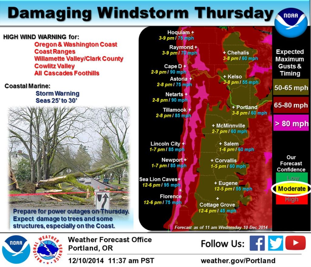
- A powerful windstorm will roll up the coast on Thursday, bringing strong, damaging winds to the region. Winds will increase rapidly later Thursday morning into the early afternoon, with south winds gusting 55 to 65 mph across much of the region. Gusts of 80 to 95 mph winds can be expected along the Coast and into the higher ridges of the Coast Range. Winds will gradually subside Thursday evening.
PACIFIC COUNTY — The National Weather Service in Portland has issued a warning to expect some of the strongest winds so far this season between 9 a.m. and 10 p.m. Thursday.
After southerly wind gusts of up to 70 mph near beaches and headlands Wednesday, on Thursday coastal communities can expect southerly gusts of 70 to 80 mph — and as much as 80 to 90 mph on beaches and headlands.
Winds will rapidly increase during the late morning Thursday along the central Oregon coast and during the early afternoon for south Washington and north Oregon coast.
Thursday’s wind will be capable of causing significant property damage, including harm to structures, the NWS warns.
Wednesday morning’s round of wind topped out at about 75 mph at Radar Ridge above Naselle and 70 mph on Megler Mountain above the Astoria Bridge. Gusts reached 52 mph at Cape Disappointment.
A high-surf advisory also is in effect from 4 a.m. to 10 p.m. Thursday. The swell is expected to reach between 25 and 30 feet with a period around 15 seconds. This will translate into intense 20-foor breakers along beaches and jetties.
“Exercise extreme caution along beaches,” the NWS said. “Unpredictable and destructive waves may wash over beaches, jetties and other structures with no warning.”
This will be a very bad week for our neighbors in North Cove and Washaway Beach.