Peninsula Rocks & Roots: Recognizing landscape features
Published 4:00 pm Tuesday, December 27, 2005
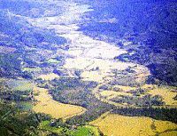
- <I>Kathleen Sayce photo</I><BR>Looking east over Grays River, this image was taken in 1996. As floodwaters receded in the Pacific Northwest, this was a common sight in many river valleys west of the Cascades in the late 1990s. In this image, Grays River has overtopped its dikes, and flooded nearly to the main sidewalls of its valley. The upper edges of a few fields can be seen, and the water is brown, evidence of sediments moving seaward.
Drowned river valleys, how local river valleys looked when they first formed Basic Concept: Our local river valleys took on their present, modern appearances when former deep river canyons flooded and filled with sediments. Ocean levels worldwide vary with the amount of ice that is locked up in ice caps and glaciers on Greenland and Antarctica, in continental ice sheets and in high elevation glaciers and snow fields in mountain ranges around the world. During the most recent ice age, the Pleistocene, sea level was as much as 300-350 feet lower than it is today. In warm, interglacial periods, sea level was as much as 200 feet higher than today.
When sea level was at its lowest during glacial maxima, the local landscape looked very different than it does now. First, tree line was at two to three thousand feet elevation in the Coast Range, above which trees did not grow. Alpine timberline descends thousands of feet down mountain slopes during ice ages.
Second, the coastline had a different shape and position. Modern estuaries, such as Willapa Bay and Columbia River Estuary, did not exist in their present locations, nor did dunes and beaches. The Pacific Ocean was some tens of miles to the west, where the North American plate ends on the continental shelf, and the adjacent ocean plate dives beneath it. During glacial maxima, the Pacific Ocean bordered a cliff at the continent’s edge in the Pacific Northwest, cut by rivers, with narrow fringing beaches and small estuary areas. River canyons cut down through sediments and soft rock, into basalt, the base rock for this part of the continent. Smaller rivers cascaded off the cliffs; many were too steep and high for salmon to swim up. River canyons were V-shaped with steep angled sides and narrow bottoms. Floods probably scoured hundreds of feet up the sides during high flow events.
There is evidence that the now-submerged river canyons of Grays Harbor, Willapa Bay and Columbia River flowed together before reaching the Pacific Ocean during glacial maxima, then diverged into three fairly close river entrances as sea level rose, unlike today’s situation, where the entrances to each of these three estuaries are at least fifteen miles apart.
Eventually the Pleistocene ice age ended and climates warmed, melting continental and glacial ice sheets. As sea level rose, the cliffs and narrow ocean beaches were submerged, then the cliffs. Saltwater moved up, flowing up and over the continental shelf, eventually reaching current shoreline position. From the present-day shoreline, the shelf now slopes gradually underwater to the west, deepening to about 300 feet at 30-50 miles offshore. At that point the slope falls more rapidly from the rocky subsurface edge of the continent to the deep ocean – the former cliffs. Sediment slopes obscure the topography of the Pleistocene coastline, which is buried under hundreds to thousands of feet of gravel, sand, silt and clay.
Local Examples: To see V-shaped river valleys with narrow small flood plains, go up into the coast range at least one hundred feet in elevation. As Highway 26 crosses the Coast Range in northwest Oregon, the upper reaches of the Nehalem River cross the road, allowing a look at a modern river that looks much like it did during the last ice age. The upper Chehalis and Willapa Rivers are also near Highway 6, and have narrow V-shaped canyons with rocky valley floors in some stretches.
When crossing the Columbia River, or driving in Naselle, Grays River, Deep River, or Willapa River valleys, note the V-shaped sides, which are truncated by wide, flat flood plains. The present surface of each valley sits atop hundreds of feet of sediment, sediment that was deposited as sea level rose at the end of the last ice age.
References, for more reading:
Local bathymetric maps
Topographic maps
Pielou, E.C. 1991. “After the Ice Age: The Return of Life to Glaciated North America.: University of Chicago Press.
Internet search words: Glacial maxima, Interglacial, Ice age.


